In 2015, IU hired a consultant to put together a master plan to support cycling on the Bloomington campus. The plan included parking, new routes, and a central hub to encourage biking. The goal was to triple the share of bicyclists on campus from about 5% to about 15%.
No plan survives contact with the enemy. Planners in 2015 could not have anticipated the rise of micromobility vehicles such as electric scooters and bicycles, and they were not aware that the city hospital would be moved from downtown out to beyond the bypass, with promises to improve the route to campus. Ballantine Hall went through a major renovation. Still, many of the recommendations were good ones and some were implemented.IUB BICYCLE HUB
A centerpiece to the 2025 Bicycle Facilities Network is the Bicycle Hub in the proximity of the Ballantine Hall/ Indiana University Memorial Union. This location is the logical nexus of daily student flow, and particularly for those who are, or will be using bicycles. Short-term bicycle parking is a central component of the covered open-air Hub, and there will be a menu of parking options including higher-end daily bike storage lockers. Depending on the Hub's proximity to the Biddle Hotel in the Memorial Union, it could include a future bike share or concierge.
Status: I suppose this was ambitious. The major student meeting place it describes never came to pass; rather a smaller (yet comfortable) bicycle storage area was added with the Ballantine Hall redesign, and Prebys Amphitheatre was constructed nearby. After a couple of years Prebys was also made part of the private residence of the president, only recently reopened to the public. The general area never became any kind of gathering area, remaining basically a crossroads.
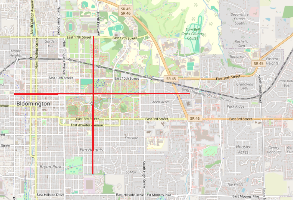
Still, if you were to place the ideal bike routes down around campus and spreading out into the community, it might look something like this:

The bike hub is almost exactly at the center of the cross. It's been placed perfectly. The east/west line is basically a completed bike route; the south line is very close. The north line doesn't work; you have to go a little west to the completed bike lane on Woodlawn, or a little east to Fee Lane, which has painted bike lanes and hopefully will get protected lanes at some point. 8/18/2024
East-West Campus Routes
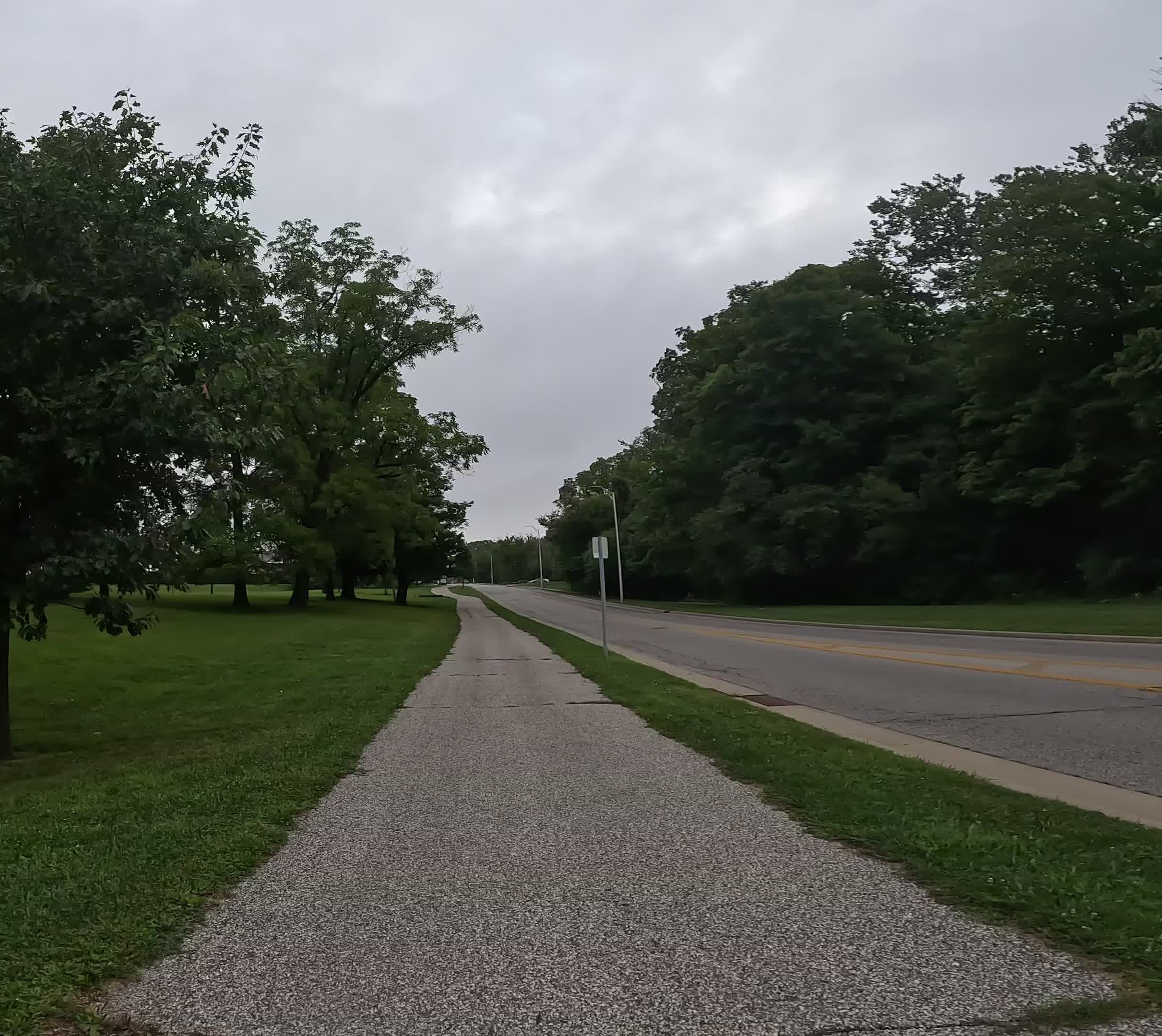
17th Street Multi-Use Path
East 17th Street is a busy and heavily used roadway especially during campus athletic events. The multi-use path adjacent to 17th Street connects the Bypass MUP to Walnut Street, with future modifications to be done by the city farther west. Bikers can conveniently head south on the Level 2 roads Eagleson Avenue or Woodlawn Avenue; Indiana Avenue (Level 3) and Walnut Street (Level 4) are additional options.
Status: This was completed as one of the first parts of the plan,
long enough ago that it should be ready to be repaved soon. East of Fee Lane
the MUP has lots of driveways and is very steep, so experienced
bikers may end up out on the road anyway. The design closely follows the
MUP outlined in the plan. 17th Street now has a MUP all the way out to the
west side so it's a useful bike thoroughfare across the city. 8/18/2024


13th Street - Law Lane Multi-Use Path
The 13th Street -Law Lane multi-use path provides an alternative to the 10th Street route with much different character. This route completes a connection from Indiana Avenue to Union Street through campus. In addition, the location of the Student Recreational Sports Center along this route will make it an important connector for many students, faculty, and staff looking for additional recreational opportunities.
Status: Probably on hold pending Law Lane modifications. Law Lane is planned to be extended from Fee Lane to Walnut Grove at 13th, and I expect that path will become a major driving thoroughfare. Hopefully it will be a complete street, with multi-use paths and bike lanes, but at the minimum it should have a MUP.
This is not a reasonable biking route currently - biking south on Indiana, you would have to make unprotected left turns onto 13th and then Law to get to the MUP that starts near Union. 8/18/2024
10th Street Bikeway
10th Street is currently lacking distinct bicycle facilities, but while the corridor is one of the busiest on campus, it’s also one of the slowest moving. This allows for bicycles to also travel as vehicles in the relatively slow traffic environment within the street. Currently, design improvements for the Woodlawn/10th Street intersection include bike lanes on a short section of 10th Street from Park Avenue to North Forrest Avenue. For this 10 year campus Bicycle Master Plan, there are also a few short segments that bike lanes may be striped in, but primarily shared use lane markings are suggested for helping accommodate bicyclists through this highly congested and constrained section of 10th Street.
Status: 10th Street is dangerous from Walnut to Woodlawn, unbikable from Woodlawn to Eagleson, and not too bad east of Eagleson. Best avoided altogether though. When traffic is diverted to Law Lane the elements mentioned in the IU Master Plan may be able to be implemented:
- Minimum 6-foot landscape edge to plant trees, allow for lighting, signage, and banners, and to separate sidewalk from road
- Landscape edge varies to create a more natural setting east of the railroad tracks
- Sidewalks 8 to 10 feet minimum, but can be wider depending on pedestrian volume Maintain low stone wall as unifying element
- Two-way bike path on south side of East Tenth Street west of the railroad tracks
- Setback/landscape zone between the sidewalk and building to feature canopy trees, understory trees, and shrub
7th Street Bike Lanes/Shared Lane Route
Status: With the 7-Line and the Greenway, 7th Street is now the ideal east-west corridor for biking between the B-Line trail and the bypass. It would be nice if the four-way stop at Eagleson could be changed to stop north-south traffic only, but a good rule of thumb for planning a bike trip is to get to 7th as quickly as possible and stay on it for as long as possible.
East University Road Bikeway
3rd Street provides a decent bike lane for westbound traffic, but there is no way to travel eastbound the same way. This would be a useful route to go eastbound, but it's incoherent at the moment.
The Plan: Create a bikeway from the Bicycle Hub up to Rose Avenue in front of Wilkie. Eastbound, travel down University, through the bike gate, and up to a path in front of the Education building that leads to a crosswalk across Eagleson. From there, Jones Avenue is one-way with sharrows, with a contraflow bike lane for westbound bikes.
Status: No bike markings anywhere, and almost the entire route has parking on both sides so cars backing out from either side are potential dangers. The path in front of Education is just a sidewalk, so you have to contend with pedestrians there. It's low traffic but you wouldn't go out of your way to use it instead of salmoning down 3rd.
Jordan River Greenway
The Jordan River Greenway proposed in this Bicycle Master Plan thus would follow the Jordan River from the location that it leaves campus near Indiana Avenue through Dunn Meadow north of the IU Memorial Union. The greenway then continues east through the proposed bike hub where it continues east, following existing sidewalks south of Woodburn Hall and the Auditorium where it crosses Jordan Avenue and runs to the north of the Jordan Avenue parking garage. After passing the parking garage the greenway turns to the north following the Jordan River as it crosses over 7th Street and then turns east again to the south of Cypress Hall where it ends at Union Street.
Status: No bike markings anywhere. The Dunn Meadow path isn't wide enough for bikes and pedestrians together, and Woodlawn to the guard house is terrible.
The proposed path circles south around the parking lot to connect with a sidewalk behind Woodburn, which is a pretty nice design although it would be all new construction. From Woodburn the path is nice and wide and goes straight to Cypress Hall, skirting the river, so it could be very pretty. There are two paths crossing Eagleson, one which is probably the intended bike path and one a few yards south for pedestrians. The pedestrian path is the only one that has a crosswalk, so crossing Eagleson is a big problem. (Crossing 7th farther on is a smaller problem, involving much less and slower traffic.)
Dunn's Woods Corridor (from Ballantine Hall to Sample Gates)
The existing east-west corridor just north of Dunn's Woods is a flow corridor for bicyclists traveling from the Ballantine Hall area through the Sample Gates to Kirkwood Avenue. The current bicycle demand is handled sufficiently with minimal bike/ pedestrian conflicts. However, as the campus bicycle infrastructure is developed, the bicycle volume on campus will increase, simultaneously increasing the bicycle flow through the Dunn's Woods corridor. As this increases, the infrastructure will need to be re-assessed.
NORTH-SOUTH CAMPUS ROUTES
Woodlawn Avenue Multi-Use Path/Bike Lanes
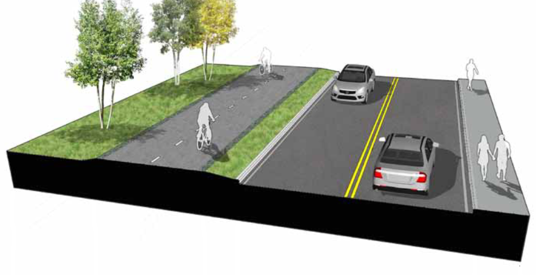
The extension of Woodlawn Avenue is providing a new and complete north-south corridor through campus. As such, this corridor has been planned as a complete street. Bike lanes are planned along the street on each side of the roadway along with an off-road multi-use path on each side. Providing both on-road and off-road facilities gives options for bicyclists of different skill levels. The Woodlawn Avenue corridor provides a direct connection between the southern portion of campus and the athletic facilities including the Stadium and Assembly Hall.
Status: Complete. Decorative brickwork around the railroad tracks make the bike lanes unusable in that area, but it's easy enough to hop onto the off-road path for a few yards.
Southbound from 17th is a hard climb up the hill, followed by a slowdown across the railroad tracks, a major intersection at 10th street, and a lot of traffic in the way if you try to turn east on 7th. Turning right on 7th is much easier, but I tend to prefer Fee or Indiana, depending on my final destination.
Northbound all the delays come as you climb the hill so they don't matter so much, and going back down the hill is blazing fast.
North Forrest Avenue Bikeway / North-South Concourse Bikeway / Arboretum MultiUse Path
Putting these all together makes a nice north-south bikeway from the bicycle hub to 10th and Fee. Add lane markings to Forrest and continue across 7th up towards the arboretum. Create a a multi-use path between the arboretum and the HPER fields. Create a bike path from this path through the arboretum to 10th and Fee.
Status: No bike markings. A tunnel under Forrest Avenue is being rebuilt and the road could be up for repaving eventually, so perhaps markings will be added then. The multi-use path is complete and the path that was probably intended to be a bike lane is complete as well. Pedestrians are everywhere in what the plan calls the "Ticket Booth" area, the south side of the 10th and Fee Lane intersection, so a good way to get from the Fee Lane bike lane onto that path is lacking. As it is, that path simply functions as an additional pedestrian path.
This route is a steep incline from Campus River all the way up to McNutt. Northbound, I much prefer going up the multi-use path, crossing 10th at the Psychology crosswalk, and heading over to Woodlawn to break up the climb. Southbound, the route is very fast and fun.
South Hawthorne Drive Multi-Use Path/Shared Lane Markings
Completing this north-south corridor includes shared lane markings on Forrest Drive adjacent to the Union parking lot then traveling slightly east on a multi-use path to connect with another shared lane route on South Hawthorne Drive. This connects the north-south route to bike lanes along 3rd Street and to the neighborhoods adjacent to the campus on the south side.
Status: The Ballantine rebuild changed this plan a bit. There's a more-or-less direct route from the Bicycle Hub to Hawthorne and 3rd, which is blocked for cars by a gate. (I'd like a little extra space to get through though. Miscalculate by a few inches and you bang your handlebar on the gate pretty hard!) No bike markings though. The city plans Hawthorne to be an important bike route.
The bike plan actually lays out a rather brilliant concept, which it does a terrible job of explaining. Combined with city plans, we have a roughly three mile, south-to-north route that goes from Hillside Street, through the Bicycle Hub, to Fee Lane at the bypass. We have another three mile, west-to-east route that goes from Adams Street through the hub, and on to 7th Street at the bypass. The Bicycle Hub sits at the center of a citywide cross that will allow you to go by bike to get close to just about anywhere.
Indiana Avenue
Indiana Avenue is a one-way, two lane street with on-street parking generally on one side of the street. The majority of it is a 30 foot wide cross-section. It is marked with shared lane markings. Its intersections adjoining the main portion of campus are stop controlled and traffic (posted) speed is approximately 30 mph. The City has proposed bike lane(s) from Hunter (south of 3rd) northward to 17th Street. This campus Bicycle Master Plan’s proposed facilities (e.g., Jordan River Greenway) will connect with the City’s future bike lane on Indiana.
As of 2024, the city is making serious progress on this. Two way, protected bike lanes are planned from Hunter to 10th Street in 2025 or maybe 2026.